Posted at 17:49h
in
Airports,
BLOG
by jescalante
LESU-ANDORRA
LESU airport is a great unknown due to its special navigation system based only in GPS
La Seu airport is an airport facility belonging to the
Generalitat of Cataluña. These facilities were opened in June 2010 with the aim of boosting tourism and economic development in the regions of the Catalan Pyrenees.
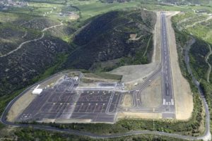
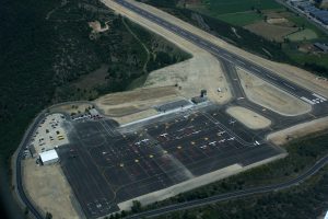
From the beginning, there have been some changes related to the operations carried out at the aerodrome and to the infrastructures. Due to its location, LESU is a very peculiar airport, located in an environment with a high mountain, and for this reason its facilities have an altitude of 2630 ft. It is operated on a 1,267 m long runway, and has a total of 41 parking stands for rotary wing aircraft and fixed-wing aircraft, in non-simultaneous use.
Currently, it has become the first airport in Spain with a published instrument flight manoeuvre based exclusively on GPS. This instrument flight system helps to improve the operation with take-offs and landings in low visibility conditions, which will facilitate the operations of commercial aircraft in said airport.
In this way, the infrastructure goes from being a visual approach airport to being an instrumental approach airport. This change, which is now in process, was launched by the
Generalitat of Cataluña together with the
Government of Andorra in 2017.
This project has been supervised by the State Agency for Air Safety (
AESA) and promoted by the airport manager of the
La Seu d´Urgell-Andorra Airport,
Aeropuertos Publicos de Cataluña,
ENAIRE,
FerroNATS and the
Technical University of Madrid (UPM), being at all times coordinated with the
Government of Andorra.
LESU, is the first case in Spain in which an approximation of this type, only with GPS system, is published on a runway verified as visual and in an extremely complex orographic and meteorological environment, for which the technical analyses have been carried out with the rigour necessary to guarantee the safety of passengers and crews. This new manoeuvring system is associated with investments for the relocation of the existing radio aids (PAPIS), as well as the performance of calibration and validation flights
The entry into force of the manoeuvre has the peculiarity that it will be "in disuse", because of the health crisis of COVID-19. Operators have been prevented travelling to Madrid to complete the mandatory training in FerroNATS. This limitation will be saved as soon as the health situation allows it.
In conclusion, as always,
Iberosime FS adapts our procedure to the needs of the operator, fly with us to this peculiar airport.
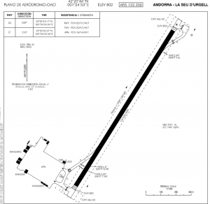
You can find attached some airport chart from LESU AIP
check info ( not use for commercial purpose)
Check this
virtual approach
By
Adrián Caro,
Technical Office Engineer Iberosime FS